
 LINKED PAPER
Distribution and flight heights of Sandwich Terns Thalasseus sandvicensis during different behaviours near wind farms in the Netherlands. Fijn, R.C. & Collier, M.P. 2022 Bird Study. doi: 10.1080/00063657.2022.2138827 VIEW
Some 35,000 pairs of Sandwich Tern (Thalasseus sandvicensis) are estimated to breed around the North Sea. The species is specialised in plunge-diving for prey and forages offshore typically up to 30-40 km from the colony. Spending a lot of time in the air makes Sandwich Terns potentially at risk of collision with offshore wind turbines, which has been suggested to vary depending on behaviour and lifecycle stage (Drewitt & Langston 2006). Since carcass searches cannot be performed at sea, collision rates in planned wind farms are typically evaluated through models, in which the proportion of birds at rotor height is an important factor determining the number deemed to be at risk. With the increase in offshore wind farms in the North Sea, and with more planned, the behaviour of Sandwich Terns at sea needs to be better understood, particularly in relation to collision risk. By assessing the flight heights and behaviour of Sandwich Terns at sea, we found that this species could be at greater risk of collision than previously thought.
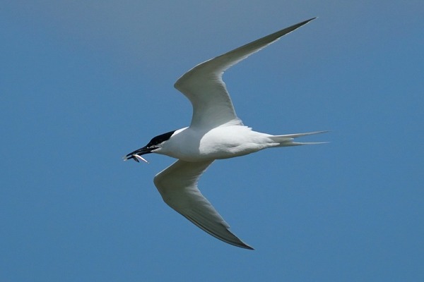
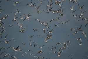
Figure 1 Sandwich Terns forage at sea and spend a lot of time in the air making them potentially at risk of collision with offshore wind turbines © Mark Collier.
Although our many tracking studies on Sandwich Terns have revealed area use and foraging behaviour at several colonies, we needed a way to assess collision risk by accurately recording flight heights, particularly during the various behavioural states. This was done using a laser rangefinder (LRF, SAFRAN Vectronix Aero 21) during dedicated ship-based surveys. These surveys were carried out in the south of the Netherlands close to the Belgian border over two breeding seasons. In 2020, the nearby colony consisted of almost 3,500 pairs and in 2021 almost 5,000 pairs bred in this area (Lilypaly & Sluijter 2021, 2022).
Over 1,550 Sandwich Terns were observed during the nearly 65 hours at sea. Most were recorded as being ‘in transit’ (n=844) with slightly fewer ‘searching’ (n=508) and fewer still as actively ‘foraging’ (n-192). Only 7 birds were recorded as ‘resting’ and these observations reflected the Sandwich Terns’ preference for alighting on buoys and similar structures. Both searching and foraging activity was often found in concentrated areas, although the exact locations varied between surveys and years and is likely linked to prey distribution (Fijn et al. 2017). Almost all prey items being carried by birds in transit could be identified as either Herring/Sprat (Clupeidae) or Sand Eels (Ammodytidae).
Accurate flight heights using the laser rangefinder were obtained for 1,230 Sandwich Terns. For a further 230 birds flight heights were estimated using standard categories (0-5; 6-10; 11-20; 21-30; 31-40; 41-50; 51-75; 76-100; and >100 m). Almost 40% of Sandwich Terns were recorded in the first 10 m above sea level and in total almost 90% were below 20 m. Just 12% of birds were recorded above 20 m and numbers decreased rapidly with increasing height. Differences were noted between behaviours, for example, no foraging birds were recorded above 40 m and the majority were between 10-20 m, whereas birds in transit were recorded above 75 m although the majority were below 10 m, especially for birds carrying prey.
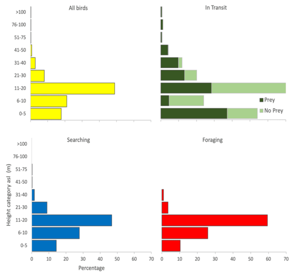
Figure 2 Flight height distributions of Sandwich Terns based on behaviour: all behaviours combined (top left), in transit (top right), searching (bottom left), and foraging (bottom right) recorded during surveys in 2020 and 2021. The distribution of birds in transit is shown for birds carrying prey and without prey.
So how do flight heights relate to collision risk?
With collisions at offshore wind farms as yet difficult to measure, predictive models are used to estimate the numbers of birds at risk. The proportion of birds at rotor height is an important factor determining the number deemed to be at risk. Comparing figures obtained in this study, we suggest that less than 1% of foraging Sandwich Terns, to up to 6% of birds in transit, fly at rotor height for a turbine with a minimum tip height 30 m above mean sea level. The overall figure of 4.1% of Sandwich terns at this risk height is over twice that of previously modelled figures and may show that collisions are underestimated with existing figures.
The recorded flight heights were comparable to those of similar laser rangefinder measurements with an identical percentage being at ‘rotor height’. We demonstrated that high-end laser rangefinders can be used to study flight heights of Sandwich Terns at sea and improve on estimates to broad classes. This method also allows information of behaviour to be collected, which can explain some of the differences in flight heights.
References
Drewitt, A.L., Langston, R.H.W. 2006. Assessing the impact of wind farms on birds. Ibis 148: 29-42. VIEW
Fijn, R.C., Jong, J.d., Courtens, W., Verstraete, H., Stienen, E.W.M. & Poot, M.J.M. 2017. GPS-tracking and colony observations reveal variation in offshore habitat use and foraging ecology of breeding Sandwich Terns. Journal of Sea Research 127: 203-211. VIEW
Lilipaly S.J. & M. Sluijter. 2021. Kustbroedvogels in het Deltagebied in 2020. Rijkswaterstaat, Centrale informatievoorziening Rapport BM 21.09. Deltamilieu Projecten Rapportnr. 2021-05, Vlissingen.
Lilipaly S.J. & M. Sluijter. 2022. Kustbroedvogels in het Deltagebied in 2021. Rijkswaterstaat, Centrale informatievoorziening Rapport BM 22.04. Deltamilieu Projecten Rapportnr. 2022-03, Vlissingen.
Funding: This study was supported by Rijkswaterstaat WVL [Case number 31154272].
Image credit
Top right: Sandwich Terns (Thalasseus sandvicensis) © Mark Collier.
If you want to write about your research in #theBOUblog, then please see here.